
In late September 2024, Hurricane John delivered an unexpected deluge to the southern coast of Mexico, leaving a significant imprint with approximately 20 inches of rainfall. This remarkable rainfall event, as estimated by NASA’s IMERG precipitation product, is visualized in the image below, highlighting the storm’s intense impact.
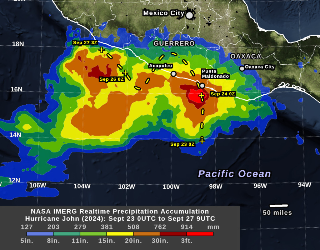 Rainfall accumulation from Hurricane John (2024) in Southern Mexico
The rainfall data, derived from a network of international satellites, validated earlier forecasts of substantial precipitation. However, Hurricane John 2024 proved challenging for meteorologists in terms of predicting its precise trajectory and strength. The scarcity of real-time rain gauges in the affected rural areas of southwestern Mexico underscored the critical importance of satellite-based precipitation estimates like IMERG for real-time storm analysis.
The image illustrates rainfall accumulation contours, ranging from 5 inches (blue) to a staggering 36 inches (bright red), recorded over a 4.5-day period concluding on Friday, September 27, 2024. The dashed yellow line indicates the National Hurricane Center’s (NHC) assessment of Hurricane John’s path.
Historical NOAA data reveals that while major Eastern Pacific hurricanes pass within 800 miles of this region of southern Mexico roughly annually, their typical direction is westward, parallel to the coastline. Notably, before Hurricane John 2024, only twice in the preceding 50 years had a major hurricane made landfall within 150 miles of John’s landfall location. On September 23, 2024, Hurricane John made landfall near Punta Maldonado, a small coastal village about 100 miles east of Acapulco. The previous instances were Hurricane Pauline in 1997 and Hurricane Otis in 2023.
Initially classified as a 40-knot tropical storm on Monday, September 23, Hurricane John 2024 was expected to only slightly intensify before landfall. Contrary to predictions, the storm underwent an astonishing rapid intensification, escalating to a Category 3 hurricane with 105-knot winds on the Saffir-Simpson scale. This dramatic strengthening occurred within a mere 18 hours just before it made landfall. The relatively low population density of the landfall region in Mexico mitigated potential societal consequences.
The National Hurricane Center reported Hurricane John’s landfall at approximately 9:15 p.m. CST on Monday, September 23, 2024 (0315 UTC on Tuesday, September 24).
Interestingly, despite forecasts of dissipation over land, the remnants of Hurricane John 2024 moved back over the Pacific Ocean. By Thursday, September 26, the system regained hurricane status, reaching 65-knot winds. The following day, it weakened again to a tropical storm before making a second landfall in Mexico, west of its initial impact.
For detailed information about the IMERG algorithm and NASA’s Global Precipitation Measurement (GPM) mission, please visit the GPM website: https://gpm.nasa.gov. Image and text credit: Owen Kelley.
References:
NOAA Historical Hurricane Tracks webpage, https://coast.noaa.gov/hurricanes.
NHC, Discussion #3, https://www.nhc.noaa.gov/archive/2024/ep10/ep102024.discus.003.shtml.
NHC, Discussion #7, https://www.nhc.noaa.gov/archive/2024/ep10/ep102024.discus.007.shtml.
NHC, Discussion #8, https://www.nhc.noaa.gov/archive/2024/ep10/ep102024.discus.008.shtml.
NHC, rain potential images, posted on https://www.nhc.noaa.gov.